Who
Goes There?: A Gilmanton Ecosystem Is Explored
Written By 7th
Grade Students Nicholas Waring, Sierra Juneau, Haleigh Patch, and Dylan
Tiede
Submitted with photos By Erin Hollingsworth
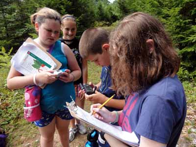
Students work together to mark and document evidence of land change
at the
CMCA as part of a science investigation.

7th grade students enjoying their field investigation of a
conservation property close to the school. Student Names (from L to R):
Corrina Marengo, Drouin Brullotte, Jessica Ladd, Alexis Jakubens and Jordan
Drew.
The 7th grade students at Gilmanton School are working on a project at
the Cogswell Mountain Conservation Area (CMCA). The project was called “Who
Goes There?” and was a good way to become field scientists and explore the
ecosystem that exists across the street from the school. There were three
groups investigating three different questions that had to do with the CMCA.
The investigations included:
What evidence is there that humans have used this area?
What evidence is there that animals have used this area?
What do the trees and the lay of the land tell us about CMCA’s past?
Each group had one of these investigations and had to find evidence
along either the Beaver Pond Trail (0.3 miles) or trail leading to the
Summit (1.6 miles) to help answer it. When the group found evidence to
support their investigation, one person would use the GPS to mark the spot
and provide the longitude and latitude so that someone else could find the
spot again. Another person would then take a picture of the clue while
someone else sketched it just in case the photo was lost. Another person
would then record data on a piece of paper describing the evidence being
observed, its physical location, as well as the number of the camera that
was used, and the number of the picture.
Reporters from each class, Sierra Juneau, Nicholas Waring, Haleigh Patch and
Dylan Tiede asked students from each group about the investigation they were
working on. One of the questions students were asked was, “Have you seen
anything interesting?” Over the course of time the three groups discovered
some very interesting clues such as a horse print, several types of scat
including moose and dog, a beaver lodge and a clump of fur on a rock. The
ground was very dry and so there were not many animal tracks seen. The
“human use” group discovered trees and a rock that was grazed over by a
snowmobile as well as old rock walls that were once used to keep the cattle
in the pasture and mark the land boundaries. Now the rock walls that were
used so long ago are surrounded by trees and forest land and that became
evidence of the land changing for that group. These are just some of
the clues that the groups had found along the trails.
Some of the evidence collected through this project may be used in the
future to teach CMCA visitors about the ecosystem of the CMCA and how humans
are a part of that ecosystem too. The lands that compose the CMCA (about 519
acres) are owned by four different landowners. They are conserved by
conservation easements held by the Town of Gilmanton acting through its
Conservation Commission, or the Society for the Protection of New Hampshire
Forests (SPNHF). The CMCA also has a brand new kiosk and map at the
beginning of the trail where some of these clues may be displayed and
changed throughout the year.
Everyone interviewed had been on the trail before but no one had been
this far on the trail. There were not a lot of actual animals seen, but
groups did see some red-spotted newts and a couple of eastern chipmunks. One
group found several geo-caches in many different places along the trail. A
fun time was had by every student while working on this project!